Remote Sensing
Remote sensing is the capability to measure something without touching it. Before the development of remote sensing techniques, the only way to take any measurement required direct contact.
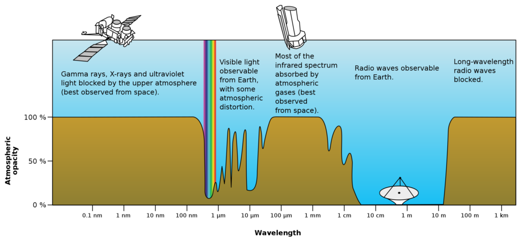
Remote sensing can be done by studying mechanical waves (like the sound), or the electromagnetic waves (EM). While mechanical waves require a continuous media to propagate, the electromagnetic (EM) waves require that the media is transparent to them. Earth transparency depends on the absorption of the molecules and particles it has.
Active vs Passive Remote Sensing
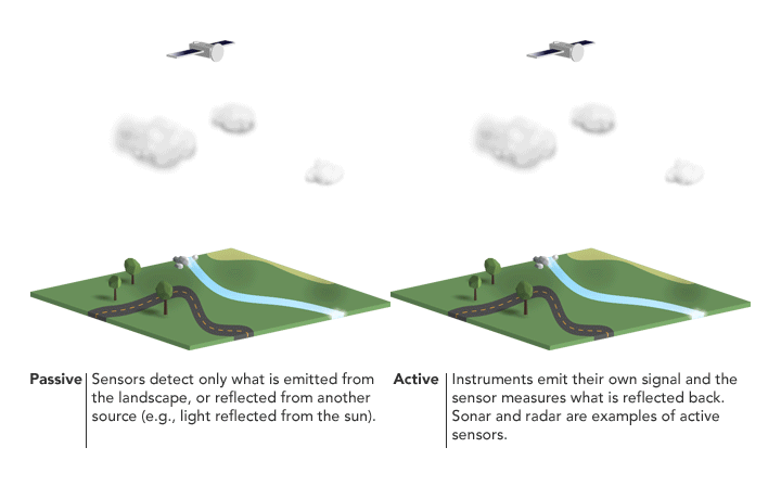
Active sensors are designed to actively create a signal or stimulus in hardware that is propagated to the Earth. The sensor detects the response that is reflected from the Earth and processes the reflected signal to extract useful information. Through the reflex of the signal sent, it is possible to retrieve the distance (the longer the signal takes to return, the further away the measured object is) or speed (by means of the doppler effect). Sonar, lidar and radar are examples of active sensors.
Passive sensors do not create nor radiate any signal or stimulus. Passive sensors detect radiated energy from natural sources like what is emitted by the landscape, radiated by artificial sources (like the Wi-Fi, TV, remote door openers, etc.) or reflected by another source. Microphones, optical cameras, microwave radiometers and reflectometers are examples of a passive sensor.
Microwave remote sensing
Microwave spectrum is divided in different bands. Depending on the frequency and the wavelength, the application is different. Following table shows some examples of microwave remote sensing applications:
| Band | Wavelenth (cm) | Frequency (GHz) | Examples of ground applications |
|---|---|---|---|
|
P (UHF) |
100 – 30 |
0.3 – 1 |
Archaeology, buried bodies |
|
L |
30 – 15 |
1 – 2 |
Soil moisture |
|
S |
15 – 7.5 |
2 – 4 |
Upper soil, vegetation structure |
|
C |
7.5 – 3.8 |
4 – 8 |
Vegetation structure, ground movement |
|
X |
3.8 – 2.4 |
4 – 12.5 |
Canopy, bare soil (subsidence, landslides) |
|
Ku |
2.4 – 1.67 |
12.5 – 18 |
Bare soil (subsidences, landslides) |
MWSE sensors
Among the different possibilities in the microwave remote sensing, Balamis is specialized in multifrequency radars and L-band passive sensors:
Multi-frequency GBSAR. Specially built and designed for slope stability control, structural monitoring, and geohazards prevention and mitigation. The system can take measurements in four different bands in less than 2 min.
ARIEL is a L-band radiometer. It is a sensor specially thought to be mobile. ARIEL series radiometer cover ground, drone and aircraft versions.
SMIGOL is a L-band GNSS reflectometer. It is a sensor thought for static applications and constant monitoring.
Educational content
If you got here looking for educational content, MWSE team suggests you to look at the introductory videos created by the Geoscience and Remote Sensing Society. It is a serie of 10 short videos in which different sensing technologies and applications are presented for kids.